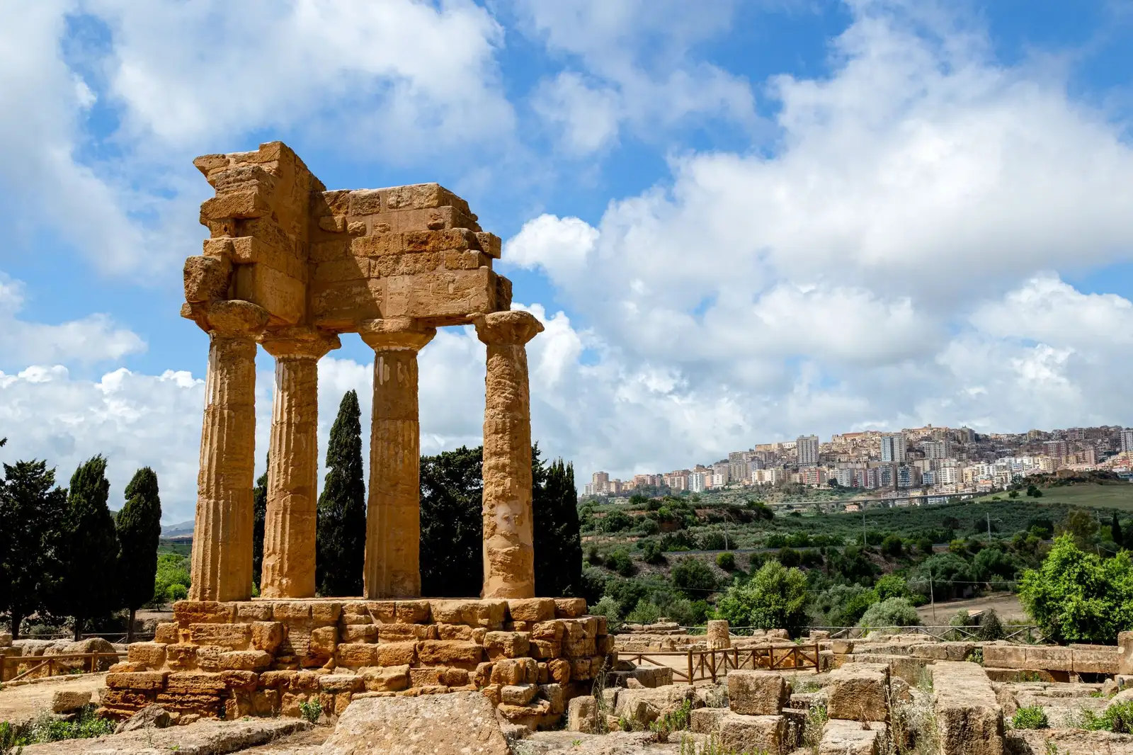

The acropolis at Agrigento dates to around 600 BCE. Think about that for a moment; you're not looking at ruins from the medieval period or even the Roman era, but from a time when this corner of Sicily was one of the most powerful Greek cities in the known world. Akragas, as the Greeks called it, was said by the poet Pindar to be "the most beautiful city of mortals." Standing among those temples at dusk, the light going amber across the stone columns, it's hard to argue with him.
This route traces the arc of Magna Graecia, the network of Greek colonies that transformed the western coast between the 6th and 4th centuries BCE. It has a clear geographic logic: starting in Agrigento on the southern coast, moving west through Selinunte, then north to Segesta and the ancient hilltop town of Erice, before finishing in Marsala where Punic, Greek, and Norman histories collide. The order matters here, and I'll explain why.
Why This Route Works
The cultural sequencing follows the historical spread and eventual contraction of Greek power in the region. Agrigento at its peak in the 5th century BCE was a city of roughly 200,000 people, a staggering number for the ancient world. Starting here puts you at the height of Greek colonial achievement before moving west toward the contested edges.
Selinunte comes next, and the contrast is instructive. Where Agrigento's temples survive in remarkable condition, Selinunte was violently destroyed by the Carthaginians in 409 BCE and never fully rebuilt. The scattered column drums and collapsed sanctuaries tell another story, one of conflict and the limits of Greek expansion westward. Visiting both within the same trip makes that contrast hit harder than seeing either one alone.
Heading north from Selinunte to Segesta and Erice marks a geographic and cultural shift. The terrain changes from coastal plain to mountain ridgeline. Segesta's unfinished temple, standing alone on a hillside since roughly 430 BCE, raises questions that still don't have settled answers; it was never completed, and why remains unclear. Erice's medieval overlay on an ancient sacred site adds another layer: the Norman castle sits on ground that was once a sanctuary to the goddess Astarte. Marsala at the end is something like a coda, Phoenician foundations, Greek influence, Roman conquest, and a wine tradition that connects antiquity to the present in the most drinkable way possible.
Map Data
Route type: Heritage Trail Total distance: Approximately 280 km by road Recommended duration: 5-7 days Difficulty: Easy to moderate (most sites involve some walking on uneven ancient terrain) Best seasons: March to June, September to November
Map center: 37.6500° N, 13.1500° E Map zoom: 9
Waypoints
| Stop | Lat | Lng | Type |
|---|---|---|---|
| Valley of the Temples, Agrigento | 37.2904 | 13.5893 | Archaeological Site |
| Eraclea Minoa | 37.3914 | 13.2728 | Archaeological Site |
| Selinunte | 37.5853 | 12.8326 | Archaeological Site |
| Segesta | 37.9394 | 12.8364 | Archaeological Site |
| Erice | 38.0384 | 12.5878 | Medieval Town / Ancient Site |
| Marsala | 37.7983 | 12.4347 | Historic Town |
The Route
Stop 1: Valley of the Temples, Agrigento
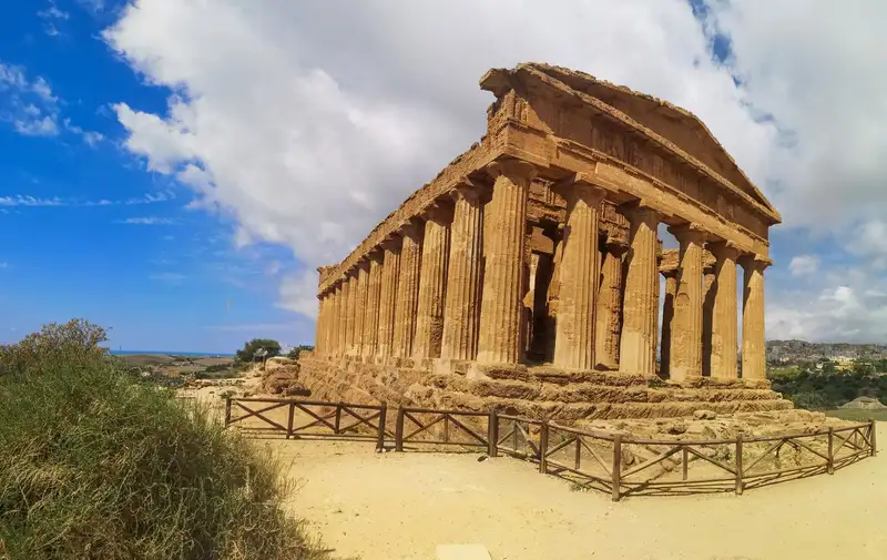
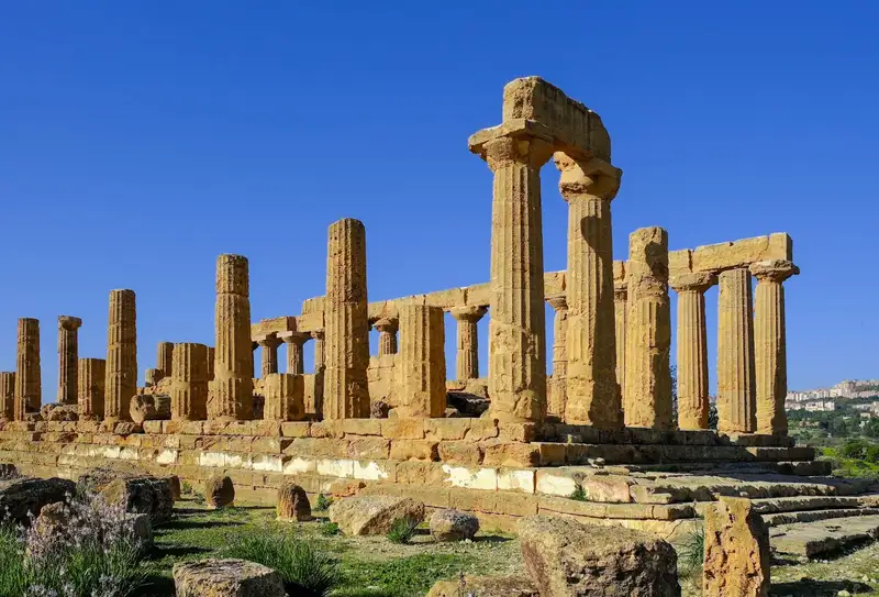
The Valle dei Templi is the anchor of this whole trip, the site where Magna Graecia culture is most fully legible. Seven temples (or the remains of seven) spread across a ridge south of the modern city, and the best-preserved among them, the Temple of Concordia, is one of the most complete Doric temples anywhere in the world. The UNESCO World Heritage listing for Agrigento's Archaeological Area covers this entire ridge and the ancient city grid above it.
Spend at least a full day here, and try to arrive in the late afternoon when tour groups thin out and the light on the sandstone turns almost gold. The Archaeological Museum of Agrigento, just above the valley in the modern city, merits a couple of hours, the telamon figure recovered from the Temple of Olympian Zeus gives you a real sense of the scale these builders were working at. The guided tour of the historical park helps untangle which temple belonged to which deity and why their placement along the ridge wasn't accidental.
This isn't simply a collection of old stones. It's a planned sacred precinct, and understanding that planning (the way the ridge faces outward toward the sea, the deliberate visibility of the temples from ships approaching the coast) changes how you read the whole site.
Transition note: Leaving Agrigento westward along the SS115, you'll pass through coastal agricultural land before reaching Eraclea Minoa, a smaller stop, but worth the detour.
Stop 2: Eraclea Minoa
Most visitors skip Eraclea Minoa entirely. Don't.
This small Greek colony sits on a white chalk headland above a beach that still looks like something from a travel photograph. The ruins here are modest compared to Agrigento (a partially excavated theater, some residential blocks, sections of the ancient city walls) but the site's isolation gives it a quality the bigger sites can't quite offer. You're standing on a promontory that Greeks settled in the 6th century BCE, and there's almost nobody else around.
The theater has a covered roof over the seating area, which is an unusual preservation measure and (honestly, that's the whole point) makes those curved rows of seats feel strangely intimate for a 2,500-year-old structure. It's a 30-40 minute stop that prepares you for Selinunte's larger scale.
Transition note: Continuing west, the terrain flattens toward the coast. Selinunte appears from a distance as a low ridge above the shoreline, the acropolis barely distinguishable until you're quite close.
Stop 3: Selinunte
Selinunte is where the story gets complicated.
Founded around 628 BCE, it was one of the westernmost Greek colonies, which put it in constant friction with the Elymian city of Segesta to the north and the Carthaginian sphere of influence to the west. In 409 BCE, Carthaginian forces destroyed it, thoroughly. The main temples on the eastern hill are a field of collapsed stone: enormous column drums lying where they fell, toppled by the attack or by later earthquakes.
Temple E has been partially re-erected, and standing next to its restored colonnade gives you a sense of what the original must have looked like. But the more honest part of the site is the unrestored western section, where the sheer scale of destruction is still plain to see. Huge metopes from the temples are now in the Archaeological Museum in Palermo, if you're heading there afterward, seeing them adds another dimension to what you've already taken in at the site.
The site is large. Allow three to four hours, and bring water in summer, the acropolis ridge has almost no shade.
Transition note: From Selinunte, the route turns north. The scenery shifts fast, from flat coastline to the foothills of the Sicani Mountains, then higher still toward the Segesta plateau. The temperature drops noticeably as you climb.
Stop 4: Segesta
What is Segesta, exactly?
The temple here (Doric, peristyle, dating to around 430-420 BCE) was never finished. The columns were never fluted. The floor of the cella was never laid. There's scholarly debate about whether Segesta was even a fully Greek city or an Elymian one that adopted Greek architectural forms for political reasons. I find that ambiguity more interesting than a clean answer would be.
The temple sits on a hillside facing east, isolated, with no other buildings nearby. A few kilometers away, up a steeper road, a Greek theater from the 3rd century BCE occupies the summit of Monte Barbaro with views stretching to the coast. The theater is still used for performances in summer (the Segesta Festival runs seasonal programming, though schedules vary year to year, check current listings before planning around them).
Together, the temple and theater make Segesta a half-day stop at minimum. Those smooth, unfluted columns give the whole place an unfinished quality that makes it feel more immediate than a completed structure. Like catching something mid-thought.
Transition note: Erice is only about 35 km northwest of Segesta, but the climb up Monte San Giuliano to the medieval town takes you above 750 meters. From the top on a clear day, you can see the Egadi Islands in one direction and the coastal plain you've been traveling in the other.
Stop 5: Erice
Erice operates on a different register than the rest of this route. The temples are gone, absorbed, built over, or dismantled. What remains is a medieval town of narrow stone streets, Norman architecture, and the Castello di Venere sitting on the highest point of the mountain where a sanctuary to the Phoenician goddess Astarte once stood, later adapted by the Greeks as a temple to Aphrodite.
The layering here is the whole point. Phoenician, Greek, Roman, Norman, each civilization found this summit useful and sacred, and each left its mark on top of the previous one. The castle itself is a 12th-century Norman structure, but its walls incorporate much older stonework. You can see the joins if you look.
Erice's pastry shops deserve a mention too. The town has a tradition of almond-based sweets going back centuries, attributed to the local convent culture. The pasticcerie near the main piazza (there are several, and the competition between them is taken seriously by locals) sell genovesi, a cream-filled pastry you won't find in quite the same form anywhere else on the island.
Transition note: Descending from Erice to Marsala takes you back to sea level and into the flat, vineyard-covered terrain of the Trapani province. After the mountain town, the visual shift is dramatic.
Stop 6: Marsala
Marsala sits at the westernmost tip of Sicily, and its position explains everything about its history. The Phoenicians founded Lilybaeum here around 397 BCE after the destruction of their settlement on nearby Mozia island. The Romans made it a major naval base. The Normans passed through. The Spanish fortified it. In 1860, Garibaldi landed here with his Thousand to begin the unification of Italy.
The Museo Archeologico Baglio Anselmi holds what I'd call the route's most unexpected object: the partially preserved hull of a Punic warship from the First Punic War (around 241 BCE), recovered from the sea off the Egadi Islands. It's the only Punic warship ever found. Standing beside it, you're looking at physical evidence of the naval battle that ended Carthaginian power in the region, the same Carthaginian power that destroyed Selinunte four centuries earlier. The route closes a circle here.
The wine is another kind of closure. Marsala wine (the fortified wine produced from grapes grown on this flat, windswept coastal plain) has been made in something like its current form since the late 18th century, when English merchant John Woodhouse recognized the potential of local production. Several historic wineries open to visitors, and an afternoon tasting in one of the old baglio (the fortified farmhouse complexes housing the production facilities) is one of those stops where the ancient and the recent stop feeling like separate categories. They never really were.
Practical Notes on Moving Through This Route
The route runs roughly 280 km by road, but the driving is rarely fast. Two-lane coastal roads, mountain switchbacks up to Erice, and the logistics of ancient site parking lots all add time. Budget for that.
For getting between stops, renting a car in Agrigento and returning it in Marsala or Trapani is the standard approach; there's no sensible way to do this by public transport, though buses do connect the main towns. If you're thinking through transport in more detail, Mastering Local Transportation: Frameworks for Efficient Mobility offers a useful framework for decisions like this one.
The Cammini d'Italia portal from Italy's Ministry of Tourism has general Sicily information, though for specific site opening hours and ticket prices, checking each archaeological park's official contacts directly is advisable, hours shift by season and have changed often in recent years.
One thing worth knowing about the Valley of the Temples: the site has an evening opening during summer months, and the temples lit at night are genuinely different from the daytime experience. Enough so that if your timing allows, it's worth arranging your Agrigento stay to include one evening visit and one daytime visit.
If you're weighing how much of this route to do independently versus with a guide, the question's more interesting than it sounds. At Selinunte, where the labeling is sparse and context requires background knowledge, a guide adds real value. At Erice or Marsala, you can move at your own pace without losing much. DIY vs Guided Tours: A Framework for Choosing breaks down that decision in a way that applies directly here.
What This Route Leaves You With
Six stops. Roughly 2,600 years of continuous human history on a relatively small stretch of coastline and mountain ridge. What makes western Sicily distinct from other Magna Graecia routes (in Calabria or Campania, say) is the compression. The Greek, Phoenician, Roman, and Norman histories don't just overlap chronologically; they overlap in the same stones, on the same hilltops.
Agrigento shows you what Greek colonial ambition looked like at its most confident. Selinunte shows you what happened when that ambition ran into its limits. Segesta asks questions it doesn't fully answer. Erice adds centuries of accumulated meaning to a single mountaintop. And Marsala connects the ancient to the present in a way that feels almost too neat, except it isn't neat at all. It's just what happens when people keep living in the same place for a very long time.
Comments (0)
No comments yet. Be the first!