The first time you see a trullo up close - not in a photograph, not through a car window - you stop. That's it. You just stop. The conical limestone roof, dry-stacked without mortar over centuries, sits there utterly indifferent to your disbelief. And somehow that indifference is the whole point of this route.
The Valle d'Itria runs through the interior of Puglia like a slow exhale - a limestone plateau threaded with olive groves, dry-stone walls, and farmsteads that predate most European nation-states. This isn't a route you race through. The towns are close enough that you could theoretically see them all in a day, but that would be like speed-reading a medieval manuscript.
What makes this trail worth planning carefully is the sequence. Start wrong and you'll understand almost nothing. Start right and each stop builds a layer of context that the next one deepens.
Why This Route Works
The Valle d'Itria sits on the Murge plateau in Puglia's interior, roughly between Bari and Taranto. Geographically, it's a karst formation - porous limestone that absorbs rainfall, which meant ancient settlers needed ingenious ways to collect water and build structures that breathed. The trullo form, with its corbelled stone dome and thick walls, is a direct answer to this climate: cool in summer, heat-retaining in winter, built from the very rock quarried to clear farmland.
The route moves from the most concentrated and iconic (Alberobello) outward through towns where trulli appear in context - scattered across farmland, embedded in village edges, absorbed into later architectural periods. This progression matters. Seeing Alberobello first gives you the visual vocabulary. Seeing the masserie and olive groves afterward tells you what that vocabulary was actually for.
The cultural layering here is also worth noting. Greek settlers from Magna Graecia arrived first, then Arab agricultural techniques during the medieval period, then Norman administrative structures after the 11th century. None of these influences arrived cleanly - they mixed, adapted, and left traces you can still read in the food, the dialect, and the spatial logic of how towns were built. Moving through the route geographically, you move through those layers chronologically, more or less.
- 1 Alberobello, UNESCO Heritage Site
- 2 Locorotondo, Historic Town
- 3 Martina Franca, Baroque Town
- 4 Masseria Landscape between Martina Franca and Fasano, Agricultural Heritage
- 5 Cisternino, Historic Village
The Route
Stop 1 - Alberobello
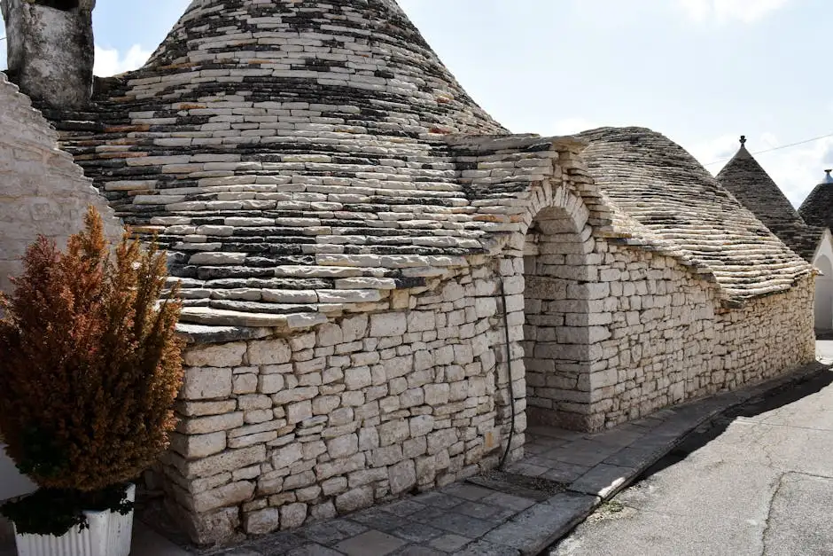
Alberobello is where the trullo form reaches its most concentrated expression. The Rione Monti district alone contains over 1,000 trulli on a single hillside, and the UNESCO listing (granted in 1996) acknowledges something visually obvious from the first street corner: this is an architectural phenomenon without real parallel in Europe.
But here's what the photographs don't tell you. The trulli were originally built without mortar partly for practical reasons - dry-stone construction allowed structures to be dismantled when tax collectors from the Kingdom of Naples came through to count taxable buildings. Whether that story is entirely accurate or partly legend, I'm genuinely not sure, but the technique itself is undisputed, and it shaped everything about how these buildings look and feel.
Don't skip the Trullo Sovrano, the only two-story trullo in the district. It gives you a sense of interior spatial logic that the smaller structures can't quite convey. Also worth your time: Rione Aia Piccola, the residential quarter next to Monti. It's far less photographed and gives you a clearer picture of how people actually lived in these spaces.
Transition note: From Alberobello, the route heads north to Locorotondo - about 8 km. The terrain opens up almost immediately, and the density of Alberobello's trullo neighborhoods gives way to scattered stone buildings in the fields. This shift matters. It's a reminder that the concentration in Alberobello is partly historical accident, partly the result of deliberate preservation.
Stop 2 - Locorotondo
Locorotondo means "round place" - and the name earns it. The town sits on a circular hilltop with a centro storico of whitewashed streets that curve around the hill's contour. Where Alberobello is all cones and stone, Locorotondo is almost aggressively white. The effect is disorienting in the best way.
Its character owes something to Greek heritage - the whitewash tradition, the layout, even some of the dialect - filtered through centuries of Norman and later Bourbon influence. The Church of San Giorgio at the center of the old town deserves more than a quick glance; the interior blends baroque decoration with an older structural logic suggesting earlier building phases.
Locorotondo is also a DOC wine zone, producing a dry white from Verdeca and Bianco d'Alessano grapes. The wine is rarely exported in meaningful quantities, which means drinking it here, at a bar on the main piazza around 6pm, feels like something that belongs to this place specifically. That's really the whole point of building a route around a region rather than individual attractions.
Transition note: The drive south to Martina Franca - about 12 km - crosses terrain that becomes slightly more elevated and wooded. The valley becomes more visible as a geographic feature here, the land dropping away to the west in a way that explains its name.
Stop 3 - Martina Franca
Martina Franca is where the route makes its most dramatic architectural shift. The baroque facades here - particularly along Via Cavour and around Piazza Plebiscito - belong to a completely different visual register than the trulli towns. This is 17th and 18th century aristocratic building: carved stone balconies, theatrical doorways, the whole production.
The town grew under the Angevins and later the Caracciolo family, who turned it into a regional administrative center. That history shows in the scale. The Palazzo Ducale, former residence of the Caracciolo dukes, anchors the old town with a kind of deliberate grandeur the smaller trulli villages simply don't attempt.
Martina Franca is also known for its capocollo - a cured pork product with a particular local character worth seeking out in the old town salumerie. The pigs traditionally grazed in the oak forests of the Alta Murgia, and that diet reportedly gives the meat a distinct flavor. Whether you notice the difference probably depends on how much capocollo you've eaten before arriving...
Every July, the town hosts the Festival della Valle d'Itria, an opera festival running since 1975 that draws performers and audiences from across Italy and beyond. If your dates align, the combination of baroque architecture and outdoor opera is hard to argue with.
Transition note: From Martina Franca, the route turns east and slightly south toward the farmhouse country - a shift from town to open countryside that requires either a rental car or serious planning if you're relying on public transport.
Stop 4 - The Masserie and Olive Groves
The masseria - the large fortified farmhouses dotting the valley - represent a different kind of heritage than the trulli. Where the trullo is a vernacular form built by peasant farmers from local stone, the masseria was a feudal institution: a working estate with dependent laborers, olive presses, wine cellars, and defensive towers against coastal raids.
Many masserie are now agriturismo operations, which creates a somewhat complicated dynamic. The hospitality industry has preserved these buildings when they might otherwise have crumbled, but it's also smoothed over the harder agricultural history. Both things are worth keeping in mind at once.
The olive groves in this zone include trees that are genuinely old - some specimens in the broader Puglia region are estimated at over a thousand years, though dating them with precision is difficult. The gnarled, hollow trunks of the older trees have a sculptural quality that feels almost architectural, which makes sense given that the olive has shaped this countryside for as long as any building has stood in it.
I think about this connection when running cooking programs in central Italy - the link between a region's agricultural logic and what ends up on the table. In the Valle d'Itria, that thread runs from the olive press to the bread to the pasta dressed with local oil, and it's clearer here than almost anywhere else I've come across in Italy.
Transition note: The final stop, Cisternino, sits about 15 km northwest of this agricultural zone - a short drive back into hilltop town territory, completing the loop.
Stop 5 - Cisternino
Cisternino is the least visited of the main Valle d'Itria towns, and that's probably because it doesn't have a single dominant attraction to anchor a visit. What it has instead is a centro storico that feels genuinely lived-in - laundry on balconies, old men on benches, a weekly market not organized around tourism.
The town's name possibly derives from the Latin "cisterna" - water cisterns - which points back to the same karst geology that shaped the entire valley. Underground water collection was survival infrastructure here, not a curiosity, and some of the older cistern systems beneath the historic center are still partially intact.
Cisternino is also known for its "fornelli pronti" - a local tradition where butchers sell grilled meat directly from their shops, a kind of spontaneous street-food culture that predates the current fashion for that sort of thing by several generations. The cuts tend toward offal and secondary meats, which either sounds like exactly what you want or exactly what you don't, but the tradition itself is worth understanding as a piece of local food culture with real historical roots. Is it the most refined meal you'll eat on this trip? Probably not. Is it one of the most honest? Almost certainly.
For anyone curious about how Italian meal culture works - the timing, the rhythm, the unspoken rules around the table - the fornelli pronti experience in Cisternino is a good case study. You can read more about those dynamics in How People Eat Together in Italy: Pace, Presence, and Unspoken Signals.
Practical Notes on Sequencing
The route runs roughly 45 km in total, but the distances between stops are short enough that driving time is almost irrelevant. What matters more is how much time you spend at each stop.
Alberobello rewards an early start before the day-tripper buses arrive from Bari (they tend to peak between 10am and 2pm). Locorotondo is best in the late afternoon and evening. Martina Franca needs at least half a day if you want to go beyond the main piazza. The farmhouse country is best explored by car, with a lunch stop at one of the working farm operations serving seasonal menus.
Cisternino works as either a final evening stop or a morning departure point if you're continuing south toward Taranto or the coast.
Spring (April to early June) and autumn (September to October) are the obvious choices for weather and crowd reasons. July and August are hot and noticeably busier, though the Festival della Valle d'Itria in Martina Franca is worth the trade-off if opera interests you.
For anyone deciding between renting a car and joining a guided group for a route like this, the arguments are real on both sides. The farmhouse country in particular is nearly impossible to explore without your own transport. A framework for thinking through that decision is available at DIY vs Guided Tours: A Framework for Choosing.
What the Route Actually Teaches
The Valle d'Itria Trulli Trail isn't primarily about architecture, even though the trulli are what bring most people here. It's about how a specific geology - porous limestone plateau, scarce surface water, thin but workable soil - shaped a human response that lasted centuries and left physical traces you can still walk through today.
Greek settlers brought agricultural knowledge. Arab presence during the medieval period introduced irrigation techniques and new crop varieties. The Normans brought administrative structures and the feudal masseria model. None of these waves replaced what came before - they layered over it, the way the trulli themselves are built: stone by stone, without mortar, held together by weight and geometry alone.
The UNESCO designation for Alberobello acknowledges the trulli as Outstanding Universal Value, but the broader valley context is what gives that designation meaning. A single trullo is a curiosity. A thousand trulli surrounded by ancient olive groves, fortified farmhouses, and baroque hilltop towns is something closer to a complete civilization in miniature.
That's what this route is designed to show. Not a checklist of conical roofs, but the logic of a place.
Route Summary
| Stop | Type | Recommended Time |
|---|---|---|
| Alberobello | UNESCO Heritage Site | Half day to full day |
| Locorotondo | Historic Town | Afternoon + evening |
| Martina Franca | Baroque Town | Half day minimum |
| Masserie Landscape | Agricultural Heritage | 2-3 hours by car |
| Cisternino | Historic Village | 2-3 hours |
Total distance: approximately 45 km Recommended duration: 3-4 days Difficulty: Easy Best seasons: April-June, September-October Base options: Alberobello, Locorotondo, or Martina Franca all work as overnight bases; Locorotondo is the most central

Comments (0)
No comments yet. Be the first!